
Stalking the wily California poppy in the western Antelope Valley. We knew the bloom was at its peak earlier in the week, so we took off after I finished with work around 4 o’clock on Thursday.
We found this dirt track off of Lancaster Road. That’s just how brilliant the poppies are!

The track turned at a fence. Pretty sure that’s the California Aqueduct between us and the hills because we encountered some water gates.

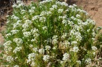
Yes, I lay down in the weeds to get this shot. And earned a pants-load of little stickery things in my jeggings. (I need some hiking pants!)

I love the silky look of the petals. You can see it on the upper petal of the far right flower.

Fences. I took lots of shots of this one.

Another view of the flowers with the aqueduct between us and the hills. You can see how the trees burned in a wild fire a few years ago.

Wonderful time to be in the desert. This will all be a lovely sepia before too long.

Looking north, I think, toward Tehachapi. You can just make out a congregation of modern wind mills at the base of the mountains, to the right.

Wind power has been a thing out here for quite some time. We also saw new banks of solar panels along our way.
Last poppy stop, a little ridge Hydra noted on the way out.
For the geologically inclined amongst you, the blue ridge to the right is, I think, Ritter Ridge. separates the beautiful Leona Valley from the Antelope Valley, and it’s also known as the San Andreas fault ridge. The Leona Valley is basically ground zero for the the plate boundry between the North American and Pacific plates. It’s gorgeous, with lots of grazing land, fruit orchards, vineyards and lakes (aka sag ponds, where the fault meets an aquifer and viola! water!)
Who’d have thougt I’d end up living on a different tectonic plate than I grew up on? Not me!